


 1 comment
"June 20, 1994” responded James Lengyel, executive director of the Martha’s Vineyard Land Bank Commission, to my question about when the conservation project for the area known for years as Red Gate Farm in Aquinnah began. “That was our first discussion,” he said of the nearly 380-acre and largely undeveloped landscape owned by Caroline Kennedy’s family since the late 1970s. In 2020, the land bank, in partnership with Sheriff’s Meadow Foundation (SMF), announced the purchase of 304 acres of the property for $27 million, followed by an additional thirty-two acres for $10 million by the land bank the following year.
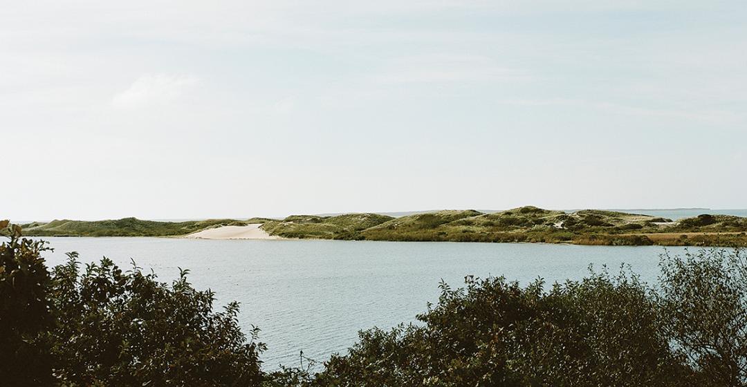
From those purchases, a 323-acre area would become the Squibnocket Pond Reservation: consistently described by nearly everyone who has visited or studied the land as one of the most majestic and ecologically distinct coastal areas in the northeast. After four years of permitting processes and management plans, the two tracts of land nestled around the remaining Kennedy holding will open to the public by late May.
Three decades of effort to protect a singular property conveys the perseverance required for land protection. And yet this key transaction is but part of a longer, grander narrative of conservation, human history, and environmental change. This tale extends to the origins of Vineyard land protection and centers on the homelands of people since glaciers formed the Island. In recognizing this history and geography we can appreciate the deeper value of this new property, the great care given to its public future, and the challenges managers face as they seek to steward it through ongoing changes.
Two conversations extended this conservation history for me. Adam Moore, president of SMF, smiled when asked of the foundation’s history with the property. Sharing typed minutes from annual meetings, he revealed that SMF sought to acquire the lands along Squibnocket Pond in the mid-1970s from the Hornblower family. Then, in 1978, The Boston Globe announced that Jacqueline Kennedy Onassis had purchased the property for $1.1 million.

Two more decades and frustration. But the tale extends deeper, exposing the origins of conservation passion to protect Aquinnah’s moorlands, coast, and great ponds. This perspective came from Brendan O’Neill, who retired in 2023 as the executive director of the Vineyard Conservation Society (VCS) after thirty-eight years. The organization has persisted, acre by acre and through policy initiatives and litigation, to knit the Aquinnah landscape together since 1965. That year, when VCS visionaries articulated the need for “proper development of real estate and protection of natural sanctuaries,” their first focus and success was containment of development of the coast, dunes, and cranberry lands reaching from Lobsterville along West Basin now held in trust by the Wampanoag Tribe of Gay Head (Aquinnah). Pivoting to the Gay Head Cliffs, VCS subsequently joined with town leadership and tribal members to apply new national legislation and have a mile of cliffs designated as the Vineyard’s only National Natural Landmark.
In the 1966 ceremony, U.S. Secretary of the Interior Stewart Udall charged the group, town, and Island with words that still reverberate: “You have here – not only in Gay Head but in this whole Island – something that is very special. The reason that it is especially prized by so many people…is that it is largely unspoiled…. I would like to think that this designation here today…it isn’t important in itself, but it is important if it imparts to all of you…a desire, a determination to perfect a conservation plan not only for Gay Head but for the whole Island…to keep it one of the magnificent places of America.”
In 1972, VCS and The Trustees of Reservations, joined by other naturalists and conservationists, produced a brief report articulating the preeminent qualities of this western end of the Island: ancient stunning cliffs of Cretaceous age, windswept moorlands, barrier beaches with towering and dynamic dunes, pocket woodlands of oak, beetlebung, and beech, and diverse wetlands, ponds, and brooks. Habitat-rich lands and water for some of the most varied plant and animal life in the northeast. A landscape that has supported one of the greatest densities of Indigenous people in New England for ten thousand years.
Topping the report’s description of the Island’s most important wildlife habitats was Squibnocket Pond and its surroundings. “Its contiguous areas constitutes perhaps the greatest wildlife biome in the State of Massachusetts,” the report noted. “It is a complete ecosystem with the best fresh water on the Island…which has one of the few remaining Alewife runs…. It includes pond, marsh and swampy areas, beach, dune, open areas, scrub, cover and a few groves of trees.”
In 2000, the town of Aquinnah codified this important natural and cultural history by joining with the Martha’s Vineyard Commission (MVC) to designate the entire township a District of Critical Planning Concern. “Aquinnah’s history of Indian habitation and the ties of the aboriginal people to the sea make this town a focal point,” the Aquinnah Planning Board stated a year prior when asking the MVC to consider this important designation.

While Aquinnah and the Squibnocket and Menemsha Ponds landscape have been a conservation priority for more than sixty years, they have a much deeper history.
Historically, Aquinnah is unique. The Wampanoag Tribe has occupied the land continuously for ten thousand years, sustaining an almost exclusively native landscape until town incorporation in 1870. With approximately one hundred pre-contact Native American and historic period archaeological sites – including more than half of the entire Island’s pre-contact sites – the sparsely-settled town has always been among the most densely-occupied landscapes in New England. As archaeologist Holly Herbster remarked, every location in town has been a Native American site and many were used repeatedly for millennia.
Though their configuration changed through time, the area’s waterways and ponds have been a consistent center of human habitation and resources. Squibnocket and Menemsha Ponds face the Atlantic Ocean and Vineyard Sound, respectively, and are linked through tidal Herring Creek. Smaller water bodies include Witch and Lily Ponds. Countless wetlands give rise to small streams. Black Brook, the largest on the new property, flows from beyond State Road to Squibnocket Pond.
A century of archaeology supplemented by new studies of pollen from three ponds on and adjacent to the property capture the area’s long-term changes in environmental condition and human adaptation. Witch Pond lies between major archaeological sites along Squibnocket Pond and the Wampanoag tribal community center. An iris-fringed, thirty-foot diameter pool sits alongside Lily Pond amidst dunes, heath, and sand. South of the property, Squibnocket Ridge Pond stands high along the cliff in dense shrubland that obscures ancient shell middens, habitation sites, and sacred areas. More than forty archaeological sites are scattered across the Squibnocket Pond Reservation.
The pond sediments pick up the postglacial story as boreal forest of spruce, jack pine, and white pine developed under a warming climate. For the next ten thousand years, the landscape remained thickly wooded, broken only by wetlands and ponds until European colonists arrived four hundred years ago and cleared the land. Through this lengthy period, the landscape changed continuously. Relentless sea-level rise reworked and eroded the coast, forming an Island that has shrunk ever since. As groundwater rose and moisture increased, ponds, wetlands, and streams became increasingly pronounced.

In dry boreal times, fire was common, ignited by lightning and leaving traces of charcoal in the muddy sediments. With further warming and greater precipitation, deciduous forests arose, dominated by oak and progressively including other tree species familiar today – red maple, beech, hickory, and beetlebung – and shrubs including winterberry, sweet pepperbush, and bayberry. It was a varied land of forested uplands and swamps, open wetlands, ponds, and coast that lacked further evidence of fire, save those in hearths.
Through millennia, the Indigenous population adapted fluidly to these environmental dynamics, adjusting subsistence and habitation strategies to tap the abundant physical, faunal, and botanical resources. As the environment ameliorated, the human population increased and fluctuated with time, supported by and living with nature, but not actively managing it. The absence of wildfire, tools to clear the land, or domesticated animals and the persistence of woodland cover confirm that Island inhabitants adjusted to the ever-changing landscape while modifying it little.
Archaeology elaborates on this theme. Native people tapped a diverse array of terrestrial, estuarine, and fresh and saltwater animal life along with many native plants. Charred nuts, berries, and even grasses are commonly recovered from the soil of inhabited sites. Tools linked to hunting, food processing, fishing, and woodworking include scrapers, hammerstones, net sinkers, drills, knives, plant and nut choppers, pestles, adzes, and gouges.
Early twentieth century archaeological explorations – assisted by Island amateurs, including members of the Hornblower family – documented approximately two dozen shell heaps along Menemsha and Squibnocket Ponds. From these and other sites, a picture emerged of resident family groups that flexibly shifted locations with changes in the environment and resources. Shelter was provided by easily-assembled but sturdy wetus or wigwams often near water. Summer sites included bluffs with cool coastal breezes overlooking large ponds and the ocean. Winter sites lay low among the woodlands and hills, sheltered from westerly and northerly winds.
The shell mounds, up to two feet in depth, were layered with artifacts and information. The shellfish – oyster, scallop, quahaug, and clam – varied with pond environments as natural openings and closings of the barrier beaches to the sea altered their salinity. Large middens along Squibnocket Pond confirm that it was often open to the ocean, as depicted in eighteenth-century maps, and supported shellfish and migrations of herring and alewife. Faunal bones reveal a strong reliance on white-tailed deer, along with waterfowl and diverse fish. The presence of a few kernels of burnt corn indicate that rudimentary horticulture arrived just a few centuries before Europeans.

Though not actively managing the land, Native inhabitants impacted the environment in countless ways. Fish and wildlife were collected, trapped, and hunted; saplings, bark, and hides were employed to frame and cover wetus; wild plants were harvested; clay was shaped into pottery; stone, bone, and wood tools were fashioned; firewood was gathered for cooking and warmth. Long-standing re-use of sites likely thinned and opened woodlands encouraging shrubs such as bayberry and winterberry that increased over the last few thousand years.
Established patterns of nature and human activity around Squibnocket Pond were transformed with European arrival and the relatively rapid adoption of colonial land-use practices, tools, crops, and domesticated animals. A major decline in trees and great increase in fire, grasses, and agricultural weeds mark the felling and burning of forests, crop production, and widespread grazing by cattle, sheep, and pigs. Grazing and fire kept the land open. Wampanoag oral tradition relates the common practice of leaving cropland fallow for several years and burning it in the spring before planting.
By 1776, maps of the Aquinnah peninsula depict extensive common lands surrounded by parcels bounded by stone walls and fences. Contemporaneous records indicate about two hundred inhabitants, four hundred cattle, and an unknown number of sheep were in the area. A visitor in 1807 described the area beyond Squibnocket Pond as “a tract of excellent land...destitute of trees…broken into hills…[with] no roads…twenty-six framed houses and seven wigwams…three barns, and two meeting houses.”
Squibnocket Pond Reservation comprised a portion of the common lands for grazing, hunting, and wood harvest along with a few small homesteads. Areas identified by land bank ecologist Julie Russell as the Amos, Solomon, and Gershom Places and the Francis and Cook homesteads appear on the 1850 Whiting Map with stone walls dividing the homesteads, one tilled field, expansive pasture, woodlands centered on wetlands around Black Brook, and open dunes along the coast.
Running over two hundred pages with details on the history and ecology of the land, the Squibnocket Pond Reservation

Management Plan, assembled under the leadership of Kristen Geagan, director of stewardship at SMF, and Russell, masterfully conveys comprehensive information on the planned management of the land and public use grounded in awe and respect for the property and its cultural history. Subject to multiple layers of review by municipal, tribal, Island, and Commonwealth officials and recommendations by passionate stakeholders, the plan was four years in revision before approval.
The text begins with superlatives concerning this stunning landscape: “sweeping views of undulating parabolic dunes” that tenuously separate Squibnocket Pond from the Atlantic Ocean and capture the property’s dynamic history. Glacial topography with “high ridges of woodlands towering over dense wetland thickets and bogs,” hummocky ridges, and long valleys. Land that has experienced minimal development as its ownership changed in recent centuries.
The 323-acre property represents the first significant joint ownership by the land bank and SMF, a precedent grounded in shared appreciation for the area and recognition of the stewardship challenges in safeguarding this fragile landscape. Environmental variation and history beget the extraordinary diversity of the place – sandy to clay soils, elevation above groundwater, distance and exposure to ocean, and human use.
The landforms and waters are preeminent features detailed in the plan. A coastal dune system unparalleled in New England consists of a series of parabolic dunes – formed when the wind excavates an existing hill or ridge of sand – that rise to twenty feet along the coast shadowed by clusters of crescent dunes – formed of the excavated and blown sands – and rising to fifty feet. A barrier beach extends nearly a half mile on the property and further onto adjoining conserved land.
Squibnocket Pond is one of the Island’s great ponds: 603 acres in area, with a mean depth of four and a half feet. It has tidal exchange with Menemsha Pond through Herring Creek, which passes beneath South Road onto tribal lands and continues to support runs of blueback herring and alewife. Absent on the 1776 map, the creek may have been cut in the nineteenth century after Squibnocket Pond closed to the sea.

Through the detailed botanical work of Geagan, Russell, and their collaborators, we learn that across the varied landscape nearly three hundred plant species comprise eight vegetation types, each with its own unique assemblage. More than a third of the property supports upland and wetland forests ranging from open oak stands and pocket woodland of beech and hickory to shady beetlebung and red maple swamps.
Another third is wetland – grassy marshes and bogs with grasses, sedges, rushes, and sphagnum, dense shrub swamps of sweet pepperbush and swamp azalea, small ponds, and two brooks – Black and Little – that feed Squibnocket Pond. Extending in from the coast, beach, heath, and dune communities support beach grass, beach heather, bayberry, beach plum, stunted oak, and grape, and transition to shrublands of huckleberry, sumac, goldenrod, and poison ivy.
Three quarters of the property is designated by the state as high-priority habitat harboring thirty-four listed species, including twenty considered endangered. Many naturalists helped document a total of 126 bird species, 458 invertebrates (including 355 moths and ninety-seven bees), fifteen mammals, three amphibians, and three reptiles.
The property represents a critical link in a cross-Aquinnah trail system and will provide superb opportunities for land- and water-based exploration. Each tract offers a trailhead with about a dozen reserved parking spaces and a trail system that will connect via kayak across Squibnocket Pond. More than five miles of trails (which will open to the public in various phases) pass viewing platforms, benches, and 2,500 feet of raised boardwalk, and access more than two hundred acres of huntable land. An existing mile-and-a-half access road and small cabin previously used by the Kennedy family will be retained for maintenance and staff support.
Constraints built into the plan seek to protect the many fragile and sacred habitats and species. Land bank rangers will supervise the property, a reservation system in season will limit daily numbers, access to some areas will vary seasonally, leashed dogs are restricted to the northern tract, horses and bikes will be excluded in early years, and swimming will be limited to the ocean.

History suggests that the property’s future will be shaped by many forces: recovery from recent centuries of land use, sea-level rise, climate change, and new human activities. The first may be most challenging to manage. All areas, from open dunes to dense woodlands, are recovering from deforestation, agriculture, and fire. Though recovery is slow in this harsh environment of wind, salt spray, and blown sand, all will gradually succeed to a shadier forested condition. One result: an ongoing decline of many familiar and uncommon plants and animals that prosper under culturally disturbed conditions. A dilemma faced by conservationists Island-wide will be especially keen here: how to steward the legacies of historical land-use.
The broad approach embraced in the management plan is to accept natural processes and change. Across most forests and wetlands, succession will advance unconstrained, dunes will form and migrate, streams will meander, and the coast will retreat gradually, filling and then consuming Lily Pond and the land surrounding it.
Active management will focus strategically and mimic recent cultural processes, principally mowing and grazing to maintain some open habitats for species that shun dense shade. This includes maintaining ten acres of grassland, clearing around old foundations and stone walls, restoring six acres of low shrubland, and sustaining twelve acres of woodland pasture and open-grown oaks. Invasive vines and shrubs will be hand pulled, cut, or girdled. Regular ecological inventories will be employed to monitor all aspects of change.
Conservation of this magnificent property contributes critical security to one of the Island’s preeminent cultural and ecological landscapes. Vineyard conservation leadership have embraced this success with great enthusiasm and humility conditioned by a sense of time and geography.
To Lengyel, this latest purchase is “breathtaking” and especially significant in the context of growth elsewhere. “The word…to describe what is happening on the Vineyard right now is ‘intensify.’ But this is a place that will remain quiet forever.”
With appreciation of successful land protection across Aquinnah, O’Neill has advised a recalibration of the frame of reference for conservation. “Measured in human terms, the effort has been long…[but it] is just a blink of the eye when viewed against the backdrop of the nearly incomprehensible antiquity of the landscape we seek to save (…from ourselves, it should be said).”
Island-wide, he noted that another 16,000 acres is in need of protection.

Comments (1)