


Joseph Chase Allen, the waterfront columnist for the Vineyard Gazette, had never seen anything like it.
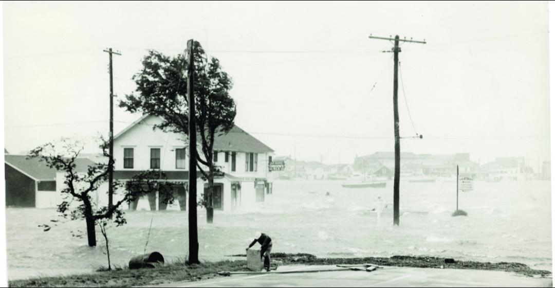
It was less the yowling of the wind than it was the way the sea rushed in. Some fishermen and shopkeepers struggling along the piers of Menemsha said it came at them like a tidal wave, but what witnesses on a hill looking down on the little seaport saw was Vineyard Sound rolling in through the jetties as a ferocious, rising river – gray, twenty feet high, heedless of boundaries and whitewater fast. It lifted and overran everything in a moment, shoving boats and shacks and piers and huge embankments of sand into the face of a hundred-mile-an-hour gale that cried at the onrushing wreckage from the opposite way.
Joe Allen had first gone fishing from Menemsha as a boy of fourteen in 1906 with Captain Everett Anderson Poole in his catboat Goldenrod. Now, on the night of September 21, 1938, he had to write a story for the Gazette about how Menemsha was gone, swept entirely away, leaving behind a plain of beaches, grounded fishing boats, floodwater, and timbers where only a few hours before a fishing village had stood. With the power out, he felt his way into his Vineyard Haven garage, turned on the headlights of his car, and began to type.
“The ruin at Menemsha Creek constitutes something unbelievable,” his story began, and trying to pull together all the things he had seen and heard, he wrote: “The circumstance which caught even the oldest and most experienced fisherman unaware was the direction of the wind, which was southeast becoming south. Wind from this direction has never been known to reach a high velocity on the Vineyard or to cause serious damage.”
Like the rest of the Northeast, the Vineyard was taken completely by surprise by the Great New England Hurricane of 1938. Never in living memory had a storm struck with such ferocity, and few thought such a storm was even possible here. New research, however, indicates that storms rivaling or even surpassing the strength of the 1938 hurricane have reached our corner of the world since record keeping began, and even long before. What’s more, with our coastlines built up and teeming with people to a degree unimaginable when the colossal tempest struck three-quarters of a century ago, scientists warn that we may be as unprepared for the next catastrophic storm as was Menemsha in 1938. It’s a matter of when, they say, not if.
“There are aspects to understanding the history that help you very much prepare for what could occur,” says Chris Landsea, the science and operations officer at the National Hurricane Center in Miami. “For example, in Massachusetts, the strongest hurricane that we believe occurred in the historical record was in 1635, the Great Colonial Hurricane.” He estimates that storm was a high-end Category 3 or a low-end Category 4; by contrast the 1938 hurricane was most likely a Category 2 storm when
it demolished Menemsha.

“Up in New England, it’s something you probably haven’t experienced, or your parents, or even your grandparents – a direct hit by a major hurricane. So it makes it more difficult to take it seriously as a threat. But when you’re looking back on the past, you say, ‘Well, it’s happened before.’ And we know with weather patterns, if it’s happened before, it’s probably going to happen again.”
“A hurricane travels like a rotating cork in a turbulent stream,” says Kerry Emanuel when trying to explain why any particular hurricane might veer north toward New England rather than hitting a more familiar target in, say, Florida. A professor of atmospheric science at M.I.T. in Cambridge, Emanuel is a leader in the effort to model how hurricanes might change in number and strength over time, based on records from the past and how the climate may be evolving now. “A hurricane is simply moving with the large-scale air-flow in which it’s embedded. When you’re in the tropics, the trade winds are relatively steady; they’re blowing out of the east, and hurricanes almost always move toward the west.”
These equatorial and low-latitude hurricanes behave fairly predictably, buzz-sawing their way across the Caribbean or into the Gulf of Mexico, varying in strength but seldom changing much in structure. But if a tropical system catches a tributary current of air that pulls it toward the Eastern Seaboard, it can be bounced around by various high and low pressure systems and behave erratically for reasons scientists do not yet fully understand.
“It’s a chaotic system that’s always evolving,” says Emanuel. “And it’s chance: when and where the hurricane gets into the mid-latitudes, what’s going on? It’s almost like a pinball machine.” Most often, even a powerful hurricane weakens as it heads north along the coastline. Cooler sea surface temperatures in the middle latitudes deprive it of energy, while adverse winds buffet, shear, and tear it apart.
But once in a while, a hurricane coming up the East Coast will combine with a non-tropical weather system. “And if the phasing is right,” says Emanuel, “it will get swept up and accelerate northward so fast that it really doesn’t have time to spin down, and that sort of interaction can even temporarily intensify the winds. And it makes for a storm – and Sandy [in 2012] was kind of an example of this – that’s a hybrid between a hurricane and a winter-type storm.”
The hurricane of 1938 was also just such a wild New England mongrel. So, very likely, were the Great Coastal Hurricane of 1806 and the Great Colonial Hurricane of 1635, the other two hurricanes in the historic period thought to rival or even surpass the 1938 tempest in strength, speed, and wrecking force. Caught and transmogrified by weather systems along the coastline and the Atlantic beyond, both storms may have hurtled northward along the seaboard at fifty miles an hour, or more, even as they devolved from purely tropical systems into vicious North Atlantic hybrids. They annihilated towns and forests on the right sides of the hurricane centers, where the forward motion adds to the speed of the winds around the core, and inundated them on the left sides, where the rain is often heaviest.
In the pages of journals, letters, logbooks, and newspapers run the stories of dozens of hurricanes that wheeled up the coast to lash, flood, and splinter the Vineyard and the rest of New England before the storm of 1938.

The Gazette went to press on September 15, 1904, for instance, reporting on a storm that had whistled just below hurricane force in Edgartown early that morning, causing the tide to rush out of the harbor at a speed estimated at eight knots.
“All sorts of theories have been advanced as to the reason for the water receding with such velocity from the harbor,” said the Gazette, “possibly one of the most plausible being that this morning a storm of hurricane, and possibly of cyclonic, force somewhere within a radius of fifty miles must have caused very low tides in Vineyard Sound and on Nantucket Shoals which resulted in practically sucking the water from the harbor, helped of course by the northwest gale blowing between 8:30 and ten o’clock.”
“A TERRIFIC STORM,” wailed the Gazette on September 28, 1888: “Sweeps over the Vineyard Wednesday Morning – Wind and Rain Unlimited – Chimneys, Trees and Fences Laid Low – No Serious Damage to Shipping in This Vicinity – The Hardest Storm Known for 50 Years Up-Island. . . .”
Or: “3rd. Wind NE. Storm Gale, Rain and High Tide,” wrote the great Vineyard diarist Jeremiah Pease in October 1841: “The Breakwater leading to the Light House is injured by the Gale, about 200 feet breaks away at night. Gale continues during Monday. 7 schooners, 3 brigs & 1 sloop goes ashore at Holmes Hole driven from their anchors.”
And so on goes the reporting, occasionally speculative and almost always awed, backward through the history of Martha’s Vineyard. The written record goes back hundreds of years. Yet the story of Island hurricanes actually reaches back much further in time, into the realm of science known as “paleotempestology” – the study of storms before the written record began. In the muck of nearby coastal ponds, scientists are finding the geologic legacies of epic hurricanes going back thousands of years.
For the past twenty years, Jeff Donnelly, his colleagues, and students have been drilling into neighboring ponds and marshes and finding the signatures of recent and ancient hurricanes in the mud and sand below the bottom. Donnelly is a geologist and geophysicist with the Woods Hole Oceanographic Institution and among the pioneers in the field of paleotempestology.
Donnelly and his team pull up metal tubes packed with earth, stratified by layers of gravel and sand that were swept in over the wetlands by the vast river-like surges of long-ago hurricanes. Radiocarbon analysis of the organic earth above and below each layer of sediment gives the date of the storm that deposited it to within a few decades or even just a few years – depending on the site, where they drill within it, and how far down (and thus back in time) they go.

“One of the things that’s really rewarding – we spent the first ten years just trying to figure out how to make it work, what the best approaches are, the best sites for it. Now we’re at the stage where we’re generating these really reliable, detailed records,” says Donnelly.
Lying just fifteen miles to the northwest of the Vineyard, where Buzzards Bay begins to funnel toward the Cape Cod Canal, Mattapoisett Marsh in particular has proven exceptionally sensitive to the sedimentary overwash from hurricanes. There, Donnelly and his team have pulled up core samples laced with coarse layers of sand left behind by tremendous hurricanes from the historic period that must, to some degree, also have swept over the nearby Vineyard in 1815, 1727, 1635 and possibly 1638, among many others.
In concert with data from other wetlands, Mattapoisett Marsh shows that “the overall storminess in terms of numbers of events probably hasn’t changed that much [going back over two thousand years],” says Donnelly. But there are times when some of those hurricanes landed here with much greater force than others.
“Rather than getting one or three Category 1’s per century, you’re suddenly getting Cat 2’s and 3’s at that frequency,” he says. For example, at Mattapoisett Marsh and other sites, he has found “really large layers” of sediment from the period between two thousand years ago to nine hundred years ago. [From roughly 1 A.D. to 1100 A.D.]
“The layers of sand are always consistently bigger and coarser, swept in by really big waves,” Donnelly says. “Initially you think, ‘Well, maybe there’s some change in the geometry of the site that’s causing this.’ But now we’ve got a dozen sites and they all point to that same conclusion. So it’s possible that during this interval, the potential intensity of these storms was greater [and] that you got much bigger hurricanes.”
Donnelly points to warmer sea surface temperatures in the tropics and less vertical wind shear as probable factors that spurred the formation of more frequent, and more intense, storms. “In that interval, it seems as though there’s lots of activity being spawned in the deep tropics that are sort of spraying hurricanes all over the western North Atlantic.”

The record of prehistoric hurricanes also reveals that not only are there extended periods when storms appear on average to be stronger. There are also times when big storms reach New England in clusters, with a frequency that stands out in the broader record.
“Records from Salt Pond, just down the road here, suggest there’s an interval between about 1440 and 1675 A.D. – and it’s more concentrated in the earlier part of that interval – that’s unprecedented in the last two thousand years,” says Donnelly. “I think there are five events that transport as much or more sediment as the 1635 hurricane, which is probably the biggest historical event. And they occur within about three decades. So you’re getting a 1635 hurricane event every six years, which is just way outside what you expect in the modern climate.”
The reasons are probably many and some are not yet entirely clear. The cluster of storms occurred during an interlude of warmth in the middle of the Little Ice Age, a period of prolonged chilliness that extended from around the early 1300s to the middle 1800s. It appears that sea surface temperatures in the western North Atlantic had warmed significantly, while the deep tropics were cooler than today. Along with other factors, this may have stifled the generation of tropical systems in the Caribbean, while encouraging them to form off what is now the southeastern United States. Many coiled into hurricanes and, caught by air currents along the coastline, raced toward us in unusual numbers and with unrivaled destructive force.
Donnelly continues to research the phenomenon. Meantime, he worries about how human activity is warming the atmosphere and seas today, and what the possible consequences may be for a New England coastline now jammed with unsuspecting people, cities, and towns.
“The scary thing with this result we’ve pulled together – this hypothesis – is, what are we doing now? We’re cranking up the sea surface temperatures to levels that are similar to this earlier anomaly. We don’t quite know what El Niño is going to do, and that is a big player. We don’t know exactly what the Intertropical Convergence Zone is going to do, but we have some ideas. But the point is, we’re turning the knobs in the right direction to go into an interval that might be analogous to some of these earlier events. What does that mean?”
It means no one yet knows what global climate change will do to the cycle of destructive hurricanes in southern New England. One line of scientific thought suggests that as the atmosphere and nearby sea surfaces warm, tropical systems may find more energy to tap into, theoretically making them stronger. But drying in the middle levels of the atmosphere and increased wind shear might also tear apart more storms aborning.
“So the global warming projections are pretty mixed,” says Landsea of the National Hurricane Center. “They suggest slightly stronger [storms] by a few percent about a hundred years from now. But they suggest substantially fewer tropical storms [transitioning] to hurricanes – on the order of 25 to 30 percent fewer tropical storms, fewer hurricanes.”
Kerry Emanuel of M.I.T. acknowledges this view, but points out that it’s really the more powerful storms that we should be worried about. “The damage is very much caused by the Category 3’s and up,” he says. “Unfortunately [the numbers of] those are due to go up.”
The prognosis for New England is made doubly hard to predict by the phenomenon of hybrid storms like Sandy and the 1938 storm. In other words, not only do researchers need to understand how climate change will affect hurricane formation, they need to understand what climate change will do to the winter-type storms that sometimes hybridize with hurricanes. “We haven’t done our homework on that,” says Emanuel, “so I wouldn’t want to say what would happen in New England.”

New England, of course, is what Donnelly of Woods Hole has zeroed in on – coastal New England in particular. “We don’t really know what the end game is,” he agrees. “It gets reported as a global mean, and they say, ‘Oh, well, slightly larger or slightly more storms, or slightly less.’ But if you look at regional differences, some regions are big winners and other regions are big losers.”
The losers could be us. Donnelly’s research shows that, among other influences, a prolonged and unusual warming of the surface of the sea off the southeastern coastline and a concurrent cooling in the tropics – caused by nature alone, with no assist from man – produced decades when the western North Atlantic and Northeast turned out to be the worst losers imaginable.
“From 1700 to today we’ve effectively been – at least in terms of the really big storms – in a relatively quiescent interval,” he says. “And now we may be transitioning into a much more active interval, perhaps analogous to some of these earlier ones, and we’ve put all this infrastructure and people in harm’s way.”
Forget Hurricane Sandy, a broad, fairly weak, lumbering hybrid storm whose surge still caused some $70 billion in damages at the seaward corner of New York and New Jersey in 2012. The sort of thing Donnelly frets about comes at us with the speed and obliterating force of the hurricanes of 1635, 1815, or most recently 1938.
“You’re destroying forests and ripping the tops of houses off into northern New England,” he says. “You’re still a catastrophic event into Vermont. It’s not just this coastal flooding and, ‘Oh, no, we’ve got some water in the subways.’ It’s a region-wide catastrophe on a scale which we’ve never seen.”
And for decades at a time – looking at the sandy layers lacing the mud that Donnelly has pulled up from the bottom of coastal ponds and marshes lying just a few miles away – it happens again and again and again.
See more: Are we ready for the next big hurricane? Habor master Charlie Blair says no.
Additional sources include Early American Hurricanes: 1492-1870, by David M. Ludlum (American Meteorological Society, 1963); Landscape and Regional Impacts of Hurricanes in New England, by Emery R. Boose, Kristen E. Chamberlin, and David Foster (Harvard Forest, 2001); The Atlantic Hurricane Database Re-analysis Project, sponsored by the National Hurricane Center; and the libraries of the Martha’s Vineyard Museum and the Vineyard Gazette.
